
Hepburn Springs
The Wadawurrung and Dja Dja Wurrung peoples had been drinking from the springs along the Yarrowee and Jim Crow creeks for thousands of years before a European settler put a name to them. The waters rose, as they still do, through a patchwork of mineral seams where carbon dioxide bubbles up from deep volcanic ground and charges the groundwater with iron, sodium, magnesium, and salt. You can taste the difference at each spring. Sharp, metallic, sometimes sour, never pleasant in the conventional sense. That peculiar taste is the whole point.
The story of European Hepburn Springs usually begins with a Swiss-Italian settler, often unnamed, who is said to have recognised the waters around 1864 from the mineral springs of his homeland. The claim is hard to verify and probably flattens a longer, less tidy history. What is certain is that by the mid-1860s word had spread, and by 1865 the colonial government had gazetted a Mineral Springs Reserve of roughly 255 acres along the valley, protecting the springs from the mining and timber-getting happening on every other creek in the district.
From Pastoral Run to Goldfield to Village
Before the springs drew bathhouses, the country drew sheep. Captain John Hepburn, a Scottish-born mariner turned overlander, established his Smeaton Hill pastoral run in 1838. The run covered ground north of Mount Franklin, including Smeaton, Kingston, and the country that would later carry his name. Hepburn himself never lived at the springs, never took the waters, and had no part in the spa culture that eventually made the village famous. He died in 1860. The first wave of Swiss-Italian settlers arrived in force four years later. The name on the map is his. The character of the place belongs to the migrants who came after him.
Gold shifted everything. The strikes at Daylesford, Yandoit, and Jim Crow in the 1850s pulled miners into the valleys and gullies around Hepburn, and with them came a wave of migrants from Ticino, the Swiss-Italian canton, and from the mountain villages of northern Italy. The Gervasoni, Lucini, Righetti, Pozzi, Borsa, Tinetti, and Crippa families worked first on the diggings, then stayed to farm. They built stone houses on steep slopes where the land reminded them of home. Pietro Lucini ran a macaroni factory at Yandoit. Others planted grapes and tobacco, baked bull boar sausages, fermented wine in stone cellars. By the 1880s, Hepburn and the surrounding ridge carried the densest concentration of Italian-speaking settlers anywhere in Australia. (For another Victorian town where gold reshaped the population in a decade, see our piece on Ballarat.)
The village that grew at the springs was unlike the gold-rush grids of Ballarat and Bendigo. There was no surveyor’s hand imposing a rectangle on the ground. Hepburn Springs followed the valley floor. A single spine, Main Road, ran along the creek line, and houses, guesthouses, and later bathhouses arranged themselves along it, some stacked against the ridge, others pushed right up to the reserve boundary.

The Italian-Swiss community left a mark on the land that is still legible today. Dry-stone walls trace the old property boundaries above the village. Stone cellars cut into the hillsides still hold wine. The annual Swiss Italian Festa, held at Hepburn to this day, traces its descent through generations of Gervasonis, Pozzis, and Righettis, many of whom still live in the district. The post-war migration of the 1950s and 1960s, when a second wave of Italians arrived from Lombardy and the Veneto, built on the chain of family networks the Ticinese had laid down eighty years earlier. The ridge above Hepburn Springs has held continuous Italian-speaking settlement for longer than most parts of Australia have held continuous European settlement of any kind.
How a Valley Became a Spa Capital
The waters needed a chemist before they could become a cure. In the 1870s, the Victorian Government Analyst’s office tested samples from the Hepburn and Daylesford springs and published the results. Soda, sulphur, and iron in measurable quantities. The analyses gave the waters a scientific credibility that prospectuses and promoters could quote, and quote they did. Within a decade the phrase “the Australian Vichy” had attached itself to Hepburn Springs, and the village was on its way to becoming a destination rather than a diggings.
The arrival of the railway in 1880 sealed it. The Daylesford branch line ran from the Carlsruhe junction on the main Bendigo route, via Trentham, into Daylesford, and passengers from Melbourne could reach the spa country in a morning. Hotels and guesthouses multiplied. The first proper bathhouse was built in 1895 by the Hepburn Mineral Springs Committee, replacing the rudimentary pump shelters that had stood at individual springs since the 1870s. By the turn of the century, the reserve was ringed with pavilions, each keyed to a particular spring: Soda, Sulphur, Locarno, Wyuna, Pavilion, Argyle.

The peak ran from the 1890s into the 1920s. Trainloads of city visitors came for the waters, the walks, and the quiet. Photographers set up on the reserve paths, selling postcards of the colonnade and the pump house. Local tensions sharpened as the commercial value of the water became clear. Disputes over bottling rights and extraction, reported in Trove’s newspaper archives from as early as 1906, set the Hepburn Mineral Springs Committee against private bottlers who wanted to draw water in volume for the Melbourne trade. The committee held the line. The reserve remained a public asset, and the bottling that followed stayed under its oversight.
The Hepburn Bathhouse was rebuilt in austere Art Deco brick in the 1930s. Then the slump came. Rail travel thinned after the Second World War. The Daylesford line closed to passengers in 1978. For three decades Hepburn lived on memory and a steady trickle of regulars, until the spa revival of the 1980s brought the bathhouse back and the Italian-Swiss Festa, still held annually, reclaimed the village’s other inheritance. The bathhouse was restored and expanded in 2008, the heritage Art Deco fabric retained and a new bathing wing added behind it. A short stretch of the old branch line now runs as the Daylesford Spa Country Railway, a heritage service for visitors who, a century after the first trains came through, still arrive looking for water.
The waters rose through the same volcanic seams they always had. The people who came to drink them changed every generation.
What a Hepburn Springs Historical Map Reveals
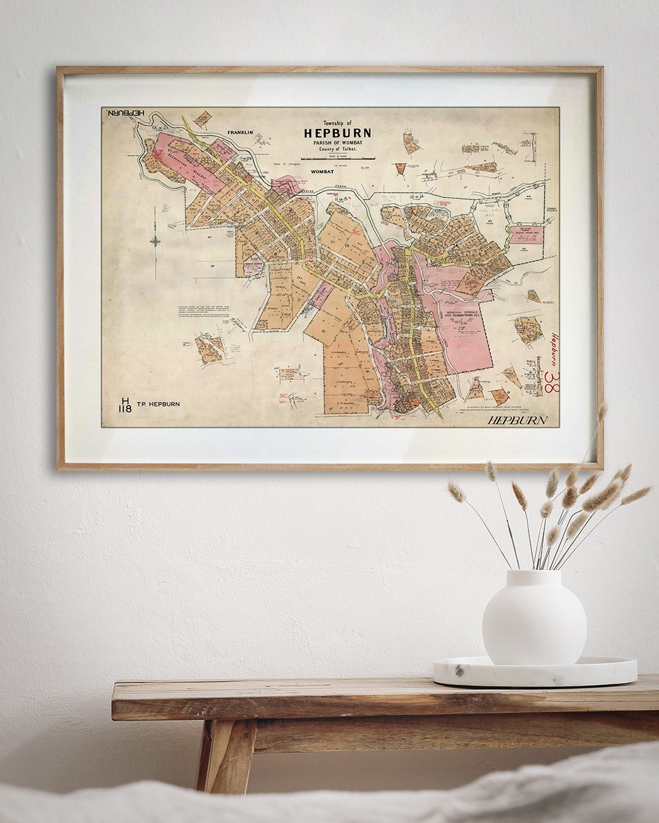
A historical map of Hepburn Springs is a map of a valley, not a town. Parish plans of Hepburn from the 1860s and 1880s, held by the Public Record Office of Victoria, show the Mineral Springs Reserve as an irregular polygon traced along the creek, surrounded by small allotments cut into steep ground. Street names are scarce because streets themselves were scarce. Main Road runs the length of the reserve. Side tracks peel off toward the ridge and the Italian-Swiss farms above. The railway line, when it arrives on later plans, loops in from the east toward Daylesford station a short distance south.
The detail rewards close reading. You can trace the pavilion sites of the individual springs, the pump house, the early bathhouse plot. You can see how the allotments on the ridge were surveyed to follow contour lines rather than compass bearings, a rare sight in Victorian cartography. The miners’ claims along Spring Creek appear as narrow strips, the Italian-Swiss farms as larger irregular blocks that climb the slopes above.
The Hepburn Township map, drawn from this era, preserves the valley as it was when the village was still finding its shape. Stand in front of it and you can pick out the reserve, the pump house, the guesthouse sites, the line of Main Road that is still the town’s spine today. For anyone who lives in Hepburn Springs, Daylesford, or the ridge country between, the map turns into something personal. You find the approximate location of your street, your block, your home, and you see what was there before your house stood, and what came before that. The Italian-Swiss farm. The mineral claim. The open valley floor where the water rose through the rocks.
A historical map of Hepburn Springs is a small document by the standards of a gold-rush town plan. The village has never been large. What it preserves is a rare kind of record: a place shaped by water and migration more than by survey, where the lines on paper follow the lay of the land rather than override it.
The Valley the Village Never Overtook
Hepburn Springs grew around the springs, not over them. The Mineral Springs Reserve remains the heart of the village, as it was when the first pavilions went up in the 1870s. The Italian-Swiss stone houses still stand on the ridge. The bathhouse, rebuilt twice, still runs hot mineral water into the same tile-lined tubs.
And the valley floor, traced by a historical map and walked by every visitor who comes for the waters, looks remarkably like the shape it held a hundred and fifty years ago.
If Hepburn Springs is part of your story, a historical map puts you inside it.
The Atlas

Hepburn Springs
Australia’s Spa Capital
A Glimpse into the Past.
Imagine a place where tree-lined streets with charming Victorian-era buildings meet mineral-rich springs, where the soothing sound of bubbling waters mingles with the rustling leaves of eucalypt forests. This isn’t fiction – it’s Daylesford and Hepburn Springs, nestled in the heart of Victoria. Let’s embark on a journey through time to explore these enchanting resort towns, guided by their stories and historic maps.
Daylesford and Hepburn Springs have long held an allure for those seeking wellness and relaxation. The discovery of mineral springs during the gold rush era transformed these towns into a destination known for therapeutic waters. The establishment of the Hepburn Bathhouse in 1895 marked the beginning of their reputation as a wellness haven.
In historical moments, from the laughter of early tourists to the sound of church bells and horse carriages, we hear echoes of the past. One can vividly imagine the vibrant scenes of early settlers discovering the mineral springs that now define the region.
Daylesford and Hepburn Springs were first settled by European squatters in the 1830s. Notably, Captain John Hepburn established a large “run” in the region in 1836. The discovery of gold in the 1850s was another pivotal moment. The towns were populated by miners during this gold rush era, and many of the now-famous mineral springs were discovered during this time. Key historical events include:
- The establishment of the Hepburn Bathhouse in 1895, marking the beginning of the area’s reputation as a wellness destination.
- The arrival of the railway in 1880, which made the towns more accessible and contributed to their growing popularity as resort destinations.
The discovery of mineral springs and the development of the Hepburn Bathhouse signaled a shift towards wellness that defines the towns today.
Cultural Significance and Attractions
Daylesford and Hepburn Springs are rich in natural and cultural landmarks:
- Mineral Springs: The area boasts Australia’s largest concentration of natural mineral springs. Key springs include Soda Spring, Sulphur Spring, Liberty Spring, Wyuna Spring, Golden Spring, and Argyle Spring.
- Wombat Hill Botanic Gardens: Located atop an extinct volcano, offering panoramic views of the region.
- Lake Daylesford: A picturesque body of water popular for recreation and relaxation.
- Hepburn Bathhouse and Spa: Established in 1895, it’s one of the oldest bathhouses in Australia and remains a major attraction.
- Convent Gallery: A 19th-century mansion turned art gallery.
- Daylesford Historical Society Museum: Showcasing the area’s rich history.
- Villa Parma: A historic building exemplifying the Swiss-Italian architectural influence in the region.
- Former Macaroni Factory: A heritage-listed site owned by descendants of the Lucini family.
Must-See Sights and Experiences
Visitors should explore the Hepburn Mineral Springs Reserve, sample mineral water from various springs, and enjoy walking trails through bushland. Lake Daylesford offers scenic walking paths, while Wombat Hill Botanic Gardens provide stunning views and a peaceful environment for leisure. The Hepburn Bathhouse & Spa and The Convent Gallery are also key attractions. Local traditions include mineral water tasting and embracing spa culture as part of the regional lifestyle.
From serene lakes to historic bathhouses, Daylesford and Hepburn Springs offer a perfect blend of natural wonders and engaging activities. As you walk through lush gardens, taste the unique mineral waters, or relax in a spa, you’ll understand why these towns have captivated visitors for generations.

Detail-Hepburn-Township-Map
Historic maps
We invite you to dive deeper into Daylesford and Hepburn Springs’ fascinating history through our collection of historic maps. These beautifully crafted pieces serve as both stunning decorative items and tangible connections to the past. Each map tells a story of how these spa capitals have evolved over the years. Our latest addition to the collection is meticulously detailed and represents these towns and their surroundings from various historical periods. Printed on high-quality archival paper and available in various sizes, it’s a perfect way to bring a piece of Daylesford and Hepburn Springs’ history into your home or office.
Browse our Daylesford and Hepburn Springs map collection today and embark on your own journey through the rich tapestry of these wellness havens’ past. Whether you’re a history enthusiast, a lover of cartography, or simply someone who appreciates the timeless beauty of these towns, these maps offer a unique glimpse into their evolution.
")


